The Living Layers of Barcelona
Published 03/30/2026 in Scholar Travel Stipend
Written
by Lina Lin |
03/30/2026
Fun Fact: Barcelona is frequently cited as the most touristed city in Europe. This reputation is well-earned, as the city boasts a wide selection of food, culture, and arts. Spending eight days here provided a valuable window to look past its Mediterranean charm and examine the city as a living laboratory of urban evolution. I went to glean how a city’s physical layout can divulge insights into its history, functionality, and cultural revolutions. In Barcelona, architecture does not simply house people; it molds perceptions and dictates the flow of life.
Medieval Foundations: The Breathless City
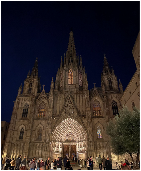
My journey began at the Cathedral of the Holy Cross and Saint Eulalia, a 14th-century Gothic masterpiece. Standing before its imposing facade at night, I was reminded that this structure is the physical heart of the Gothic Quarter, a beguiling tangle of medieval alleyways. Interestingly, while the interior is a model of 14th-century Catalan Gothic, the facade was reimagined in the late 19th century to reflect the city’s growing wealth and its desire to project a polished, historic image to the world.
However, by the mid-1800s, this medieval “anchor” had become a cage. The MUHBA (Museum of the History of Barcelona) exhibits reveal a city trapped within its own Roman and medieval walls, leading to extreme overpopulation and health crises. With densities reaching 800 inhabitants per hectare, the airless streets of the old city were breeding grounds for disease. This desperation for “breathing room” is exactly what sparked a radical shift from organic, accidental growth to the scientific discipline of urban planning. As I explored the museum’s “Topographies of Growth,” it became clear that the demolition of these walls was not just an architectural choice, but a necessary “leapfrog” strategy to ensure the city’s survival.
The Science of Urbanization: Cerdà and Lynch
This transition from chaos to order was spearheaded by Ildefons Cerdà, who famously coined the term “Urbanization” in his 1867 treatise to describe the logic behind his 1859 Expansion Plan. At the MUHBA, I delved into how Cerdà revolutionized the field by viewing the city not merely as a collection of static buildings, but as a dynamic series of intervies (interways). To Cerdà, the “spaces between” the streets, the unbuilt areas, were just as critical as the structures themselves, serving as the essential conduits for air, light, and movement that the medieval city lacked.

This transition from chaos to order was spearheaded by Ildefons Cerdà, who famously coined the term “Urbanization” in his 1867 treatise to describe the logic behind his 1859 Expansion Plan. At the MUHBA, I delved into how Cerdà revolutionized the field by viewing the city not merely as a collection of static buildings, but as a dynamic series of intervies (interways). To Cerdà, the “spaces between” the streets, the unbuilt areas, were just as critical as the structures themselves, serving as the essential conduits for air, light, and movement that the medieval city lacked.

This scientific approach to the “legibility” of a city was later echoed by the American urban theorist Kevin Lynch. In the museum’s "Paisatges" exhibit, I saw how Lynch’s five categories: paths, edges, districts, nodes, and landmarks, provide a mental map for navigating and understanding the urban landscape. In Barcelona, the Exiample is a perfect Lynchian “district”:
● Paths: The relentless, wide avenues visible from above that facilitate both transit and long sightlines.
● Nodes: The chamfered, octagonal corners at every intersection. From an aerial view, these “nodes” create a rhythmic, repetitive pattern that makes the grid predictable and easy to navigate.
● Edges: The district line where the dense, irregular medieval “fabric” abruptly meets the rationalist expansion of the grid.
By applying Lynch’s framework to Cerdà’s grid, it becomes clear that the Exiample was designed to be “read.” It replaced the disorientation of the “cage” with a geometric clarity that facilitated both social equality and economic efficiency.
The Vertical Hierarchy of Exiample
Walking through the Exiample, I observed Cerdà’s 19th-century “vertical stack” in action. Looking up at the ornate balconies, I could visualize the social hierarchy:
● The Ground Floor: These spaces are built flush with the sidewalk to invite commercial vitality, ensuring that trade and daily life are inextricably linked
● The Principal Floor: This level is clearly distinguished by its elaborate stonework and expansive balconies; as the residence of the building owners, it served as a public display of wealth and status
● The Upper Tiers: You can see the windows and balconies shrink progressively higher up; in an era before elevators, these floors were typically reserved for the working class who had to endure the longest walkup and the smallest quarters

The Evolving Constraints of the Grid
However, as the 20th century progressed, even Cerdà’s visionary grid began to feel the constraints of its own success. The very “commercial vitality” and high-density mixed-use planning that once liberated the city eventually led to a new kind of enclosure: an industrial and infrastructure “belt” that severed the Exiample from the Mediterranean coast. By the 1980s, Barcelona found itself at another crossroads, landlocked by decaying warehouses and rail lines that turned the city’s back to the sea. This stagnant industrial edge became the next “cage” that required a radical, strategic intervention to maintain the city’s economic momentum.
The 1992 Pivot: Turning to the Sea
The city’s ability to reinvent itself became most tangible on my final day. I took a leisurely stroll through the waterfront promenade, the very area famously altered for the 1992 Olympics. The Games served as a masterclass in “urban acupuncture,” leveraging a global moment to surgically reclaim kilometers of industrial waterfront for public parks and beaches. Walking under the palm trees, I realized this promenade is the ultimate “edge” in Lynch’s terms: a once-impenatrable boundary that has been successfully transformed into a vibrant site of leisure and economic activity.

Conclusion: The Human Topography
As I analyzed the “Topographies of Immigration” at the MUHBA, the final piece of the puzzle clicked into place: a city’s design is only as successful as its ability to absorb and integrate new “fabrics” of people. The Barcelona Model demonstrates that when a city is designed with “legibility” and “breathing room” at its core, it creates a resilient structure capable of withstanding the shifting topographies of global migration and economic change. This synthesis of history, design, and policy offers a profound blueprint for how 21st-century leaders can foster sustainable, inclusive growth in an increasingly urbanized world.

Citations:
Garcia-Espuche, A. (2002). The Barcelona Model: 19th Century Urbanism. Barcelona: Museu d'Història de la Ciutat.
McNeill, D. (1999). Urban Change and the European Left: Tales from the New Barcelona. Routledge.
Cerdà, I. (1867). Teoría General de la Urbanización (General Theory of Urbanization). Madrid: Imprenta Española.
Lynch, K. (1960). The Image of the City. MIT Press.
Busquets, J. (2005). Barcelona: The Urban Evolution of a Compact City. Nicolodi.
Marshall, T. (Ed.). (2004). Transforming Barcelona. Routledge.
Resina, J. R. (2008). Barcelona's Vocation of Modernity: Rise and Decline of an Urban Image. Stanford University Press.
Author(s):
